In 2010 and 2011, the Maryland State Highway Administration (SHA), the US Navy, and Maryland Historical Trust (MHT) conducted archaeology surveys in the Patuxent River on a War of 1812 shipwreck. This blog documents our underwater archaeology surveys.


July 12, 2011

Amazing Progress

Today it was 95 degrees under our shade canopies--jumping in the water to swim in pea soup water was a welcome relief. Both teams have found the wood of the wreck in their trenches.  The water visibility was very poor due to last night's unexpected thunderstorm, but we still were able to dredge down and feel the shape of the wreck.  Since you can't see the wood, there is a different type of excitement when you feel the ship....your hands take in the shape and smoothness of the architecture. It is a magical experience to think that 200 years ago Joshua Barney ordered his men to scuttle his flotilla, and here it is nestled beneath twigs and sand just waiting to reveal its secrets. Tomorrow we continue on dredging trying to learn more about the size and shape of the site.
Lee Cox and Julie Schablitsky hold on to the ladder to keep from being swept up stream.
Diver probes out wreck to verify their location.

July 11, 2011

Already on the Wreck


Today, there were two teams of archaeologists working on the the bow and stern of the wreck--we are not sure which end is which, but we should find this out by the end of the week. Based on the hydroprobing results, the wreck appears to be at a bit of an angle in the river and is orientated in a northwest to southeast direction.

View of map showing hydroprobe results with the black line delineating the baseline.

The north, or upstream, end of the wreck was reached this afternoon.  A 10 ft. x 6 ft. trench was dredged down on the north end of the wreck to try and delineate the edges and end. We stopped at the clay silt stratum that encases the wreck. During the dredging, a piece of worked pine wood was encountered and immediately placed back in water on the barge for conservation.
Worked, pine wood piece found just on top of the wreck this afternoon. 

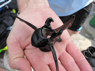
While the northern end of the wreck was being delineated, the second team of archaeologists worked to expose the southern end of the wreck. During the dredging of the sandy overburden, an animal bone popped up that looks like a vertebrae from a deer or other medium sized mammal.  Since it was not in direct association with the wreck, it may just be a random bone deposited in the more recent past. 

A medium sized mammal vertebrae recovered from the sandy stratum above the wreck.


Tomorrow, we will be back on the wreck and may even begin screening the thin, silty-clay stratum over the wreck. Make sure to visit MPT's blog on the making of Search for the Scorpion.

The bubbles on the left and then on the right show divers dredging the ends of the wreck.


July 8, 2011

All Hands on Deck

Today the metal shoring to hold back the sediment in our excavation units arrived at the Patuxent River Park.  MNCPPC loaded the shoring onto a flat bed truck and transferred it up river to the Patuxent River Trailer Park and down to the boat ramp where several US Navy divers assembled, attached the shoring to the side of their boat, and moved it to the shallow waters of the river within reach of the site.

Watch a short clip of Navy Divers and others unloading shoring, working on the barge, and filming of the action.

While the Navy was busy moving shoring, the rest of the crew set up and organized the barge, readying it for diving.  Maryland Public Television (MPT) was there to capture the action.  MPT also documented conversations between Susan, Bob, and Julie discussing how to first excavate the wreck. The excavation will begin on the ends of the wreck as well as the center.  Last year we came away with only a curious lead weight---but this year we will encounter artifacts in the hold of the vessel. In addition to the artifacts, we also expect to understand the condition (e.g. did the sides collapse outward) and orientation of the wreck.
 US Navy divers attaching shoring to boat.
 Shoring ready to be assembled.
Dr. Susan Langley talking to Mike English and Tim Pugh.

In addition to organizing shoring and filming, we also tested the pumps to ensure we can start dredging away the sediment first thing tomorrow morning.

July 7, 2011

Phase II of the 2011 Archaeology Project Starts Tomorrow

 After a two week break, we will be back excavating on the wreck tomorrow. It took a few days to mobilize the barge and equipment and float it up the river from Selby's Landing at the Patuxent River Park.  But, we now have a 38 ft. x 18 ft. aluminum barge anchored near the site along with a bright yellow sediment curtain.  Once excavation starts, the overburden will be pumped into the sediment curtain to keep it from going down river. Tomorrow we will be assembling the metal shoring and removing some overburden that now sits atop the wreck.  Maryland Public Television will also be arriving in the late afternoon to capture footage for a 30 minute documentary on the USS Scorpion archaeology project. Be sure to check back for our daily updates through the first week of August.


View towards southwest of aluminum barge. The yellow tanks hold water to rinse dive equipment. The wreck is located on the opposite side of the barge.

June 17, 2011

Back on the Patuxent!

This week we returned to the Patuxent River to gather information on the exact coordinates of the wreck and the depth of the sediment overlying the site. A drilling rig worked along side of us and collected two, 6 in. bores to a depth of 50 ft. Understanding the type and location of the strata help our engineers to determine how to build and install the proper cofferdam. The depth of the sediment over the wreck and the height of the hold are also figures that must go into the cofferdam construction equation.
Underwater archaeologists working off boats as they set up the excavation grid (above).

If we do have the USS Scorpion, the ship would have measured about 60 ft. in length, and about 16 ft. in width. The hold would have about a 5 ft. clearance--just enough room to store the sailor's belongings and rations. Based on our metal rod and hydroprobe results, the sediment over the wreck ranges from 3 ft. to just over 9 ft. The water is approximately 9 ft. in depth over the site during high tide, but can drop several feet during low tide.


Wes Hall and Lee Cox document the location and depth of their probes (below).

We will be working through the weekend and should be finished by the middle of next week. Taking the results from this survey, we will use it to determine the placement of larger excavation units along the edges of the wreck and hopefully within the hold area. On July 6th we will mobilize a large barge near the site and excavate at least half a dozen excavation units and conclude the testing during the first week of August.

February 2, 2011

Preparing for Summer Survey 2011

Good news! It looks like we will be back in the field for another season. Two of our main goals for this summer will be to hydroprobe and delineate the known wreck (possible USS Scorpion) and to determine if we have additional wrecks in this stretch of the river. Remote sensing data looks very suspicious and we are wondering if we could have the entire flotilla. The combination of hydroprobing and excavation this summer will hopefully answer these questions.

While the next several months will be filled with drafting legal documents and moving through the environmental permitting process to dive and excavate on the wreck this summer, we are also feverishly looking for funding. We are close to securing the full amount to construct the cofferdam, but continue to search out sources of funding and grants. Wish us luck!

October 26, 2010

Fall Update

Just an update to let those of you following the project that we are in the process of identifying funding. It looks like we may have enough cobbled together for another survey in July 2011, but our time for finding matching money for our Transportation Enhancement Program funding is running out. All we need is a mere million dollars to fully fund the construction of the cofferdam and excavate the wreck in 2012!