In 2010 and 2011, the Maryland State Highway Administration (SHA), the US Navy, and Maryland Historical Trust (MHT) conducted archaeology surveys in the Patuxent River on a War of 1812 shipwreck. This blog documents our underwater archaeology surveys.
We spent the day on Friday cleaning and preparing the site for filming by Nick Caloyianis. Nick is use to filming in blue waters, so the murky waters of the Patuxent River provided a real challenge for him. Using state of the art equipment and after taking multiple dives, Nick captured the curve of the ship including decking and iron fittings and fasteners. The film footage will be wrapped into a 30 minute documentary being produced by Maryland Public Television. This will be the first time the public will see one of the ships scuttled by Commodore Joshua Barney almost 200 years ago.
Nick checks the "dive cam" attached to George's head.
This is not a ROV, but Nick's camera.
Nick prepares to enter the water.
We also had two sets of visitors. Our colleagues from the Maryland Archaeology Conservation Laboratory paid a visit as did Anne Arundel County archaeologists who are excavating an awesome multi-component prehistoric site down at Pig Point.
Nichole, Kate, and Drew pose with underwater archaeologist/conservator George Schwartz.
Dr. Julie Schablitsky gives Anne Arundel County archaeologists a tour from their boat.
Yesterday was a busy day on the barge. Although our focus has been the wreck, we also had to ensure that an adjacent magnetic anomaly was not associated with the site. Heading back to the approximate location of the signal, a diver used a handheld magnetometer to find the anomaly and began to dredge. Could it be an anchor? a canon? Several feet later, we found a buried metal conduit of no historical value whatsoever.
Wes Hall holds a magnetometer used to pinpoint magnetic anomalies.
After solving the mystery of the unknown metal anomaly, we turned our attention back to the War of 1812 vessel. Using the bow as a starting point, archaeologists used a probe to find the starboard and port sides of the ship. White PVC pipes were placed at these points. After all of the white pipes were in, the shape of the ship popped right out of the water; this is an important visual aid for both the archaeologists and our VIP visitors.
This video shows the outline of the wreck with white plastic pipes.
Speaking of visitors, Suzanne Copping, National Park Service (NPS), Program Manager for the Star Spangled Banner National Historic Trail, and Cindy Chance, NPS communications specialist, took a boat tour around the site and hopped on the barge to talk to the divers. The NPS is a significant partner in this endeavor. New information gleaned from these excavations will be used in their War of 1812 literature, signage, and other media.
Vince, Dr. Langley, and Suzanne Copping from the NPS pose for a photo.
During the dredging activities, we often recover architectural artifacts associated with the wreck. The one artifact that gave us pause, was a very light, but black piece that looked like wood. The lightness and color of the material suggests it may be tar. Tar has been produced here (primarily from the pine stands of Virginia and North Carolina) since the colonial-period. Since it was used for patching and waterproofing, this sticky substance was aboard every wooden sailing vessel in the world. Tar could be applied to all parts of the ship, including the rigging and canons. The piece here retains the wood grain on one side and a smoother dimpled texture on the other. It appears as if the tar solidified in a wooden barrel or box.
Smooth dimpled side.
Wood grain texture captured in tar.
Today will be a busy day on the barge with the arrival of Nick Caloyianis. Nick is a world renowned underwater videographer who will be diving on the wreck capturing footage for the Maryland Public Television documentary, Search for the USS Scorpion. He regularly films footage for shark documentaries, but today the only thing he needs to worry about is a random river leach.
At the end of the week, we found ourselves on a floating barge working in extreme heat, but at least we were on the water. We have completed the excavation in two of the trenches. The upstream end has been nicely exposed and we are mapping and filming underwater to document the bow.
The downstream trench now has archaeologists measuring and mapping the large beams and decking--it does not appear that we have found the stern, yet. We are also continuing to excavate in the center of the wreck. Archaeologists working in this area are down to the decking. They found a long iron strap with rivets that was lying atop, but not attached to the wreck.
Dr. Robert Neyland prepares a video camera for underwater documentation. The camera is a great addition to a project that has poor water visibility, it picks up much more detail than the human eye.
While mapping the wreck, we are picking up any artifacts that seem to be loose and not in situ. Around the end of the wreck, we found what appears to be a pig bone. When the site was examined in 1980 by author Don Shomette, large holes were excavated and at some point appear to have been backfilled with modern sediment and debris. Since the sediments have been disturbed, we are not sure if this bone represents mid-20th century garbage or a sailor's ration. We will be forwarding the images of the bone to a faunal analyst for a positive species identification.
Medium sized mammal bone.
Another interesting artifact recovered from the bow was a deadeye. Deadeyes are used for ship's rigging. Our deadeye is a on the smaller side (approximately 5 in. x 10 in.) and is missing the wooden center with three drilled holes. The two holes on top and the one in the center give it this hardware the appearance of a skull...hence the name.
Deadeye found near bow.
Example of 19th century deadeyes incorporated into ship rigging (courtesy shutterstock.com).
In addition to artifacts associated with the wreck, we are also coming across coffee cans, beer cans, glass, etc. On Friday, a leather sole popped up from the end of the wreck. It measured 11 in. long and was for a man's left foot. It looked old, but it was not from the War of 1812 wreck. Footwear was not regularly made in "lefts" and "rights" until the mid-19th century.
Bottom leather sole from a man's shoe or boot (post-1850).
Monday we will be back out on the site and will continue searching for the stern and the sides of the wreck. We only have two weeks left to find out the size of the shipwreck.
As archaeologists, we are always excited to find artifacts and based on the items removed from the wreck 30 years ago, we will not be dissapointed. The value of the artifacts is not monetary, but in the information they contain and what these personal items can tell us about the sailors who fled the flotilla 200 years earlier.
In shipwreck archaeology, it is not only what's on the inside that counts, but what's on the outside. Although we are diving in "black water" with visibility of only a foot or two, it is still possible to make out where ropes once passed and even see and feel a groove that may be a wash board. Although the upper reaches of the wreck have been partially damaged from exposure above the water line decades earlier, some of the decking was quickly buried in the sediment, preserving a freshly milled color.
Diver Dan's sketch of the upper end of the wreck.
While diving, Dr. Bob Neyland brought up a few old beer cans, including his favorite, Miss Olde Frothingslosh. This beer was marketed by a Pittsburgh brewer in the 1970s.
Yesterday, SHA District 3 Marlboro Shop helped keep us safe by constructing wooden decking across our barge. The barge we rented came with raised plates, hooks, and other tripping hazzards that made walking dangerous. A big THANK YOU goes out to Carlton and Jim for keeping us safe!
Carlton takes a measurement for the decking.
Jim cuts notches on the beams to fit around the tripping hazzards and feeds them over to Carlton.
Today, we excavated a large amount of sediment from both ends of the wreck. Within the next day we should expose enough of the exterior of the hull to feel the shape and understand a bit more about the architecture. The downstream end is full of heavy timbers and may represent the bow....but, we just don't quite have enough exposed to know at this point. Tomorrow we should know the length of the shipwreck....any guesses?
Another busy day on the barge. Part of the duties of an underwater archaeologist is to keep the pumps running.
During all of the dredging away of the sediment, we often find pieces of garbage in the overburden. Today we brought up and tossed out a clay pigeon, long glass tube florescent light, coffee can, bottles, and a golf ball. At the end of the day, we found a large jaw bone that may have belonged to a horse. We joked about how Barney had cavalry in his flotilla. In reality, this bone was found outside, but adjacent to, the upstream part of the wreck--so it may have washed in at anytime during the last 200 years. A faunal analyst will be making the final identification for us.
UPDATE: Dr. Guy Tasa identified the bone as a cow madible, left side. Thanks Guy!
Although we did not remove much overburden across the wreck today, we did map in some important points, including the northern end of the wreck site. In addition, we maneuvered the heavy 12 ft. long shoring into place that should cover part of the hold. Since the shoring is so heavy, we used plastic lift bags filled with air to help position the box over the exact spot.
Troy Nowak, Assistant State Archaeologist, discusses placement of shoring with US Navy underwater archaeologists Brad and George.
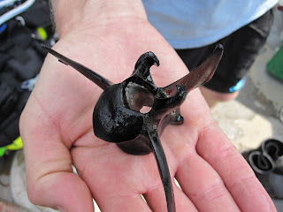
While exploring the northern part of the wreck we came upon a curious piece of wood. It was a barrel stave! It measures 22 in. tall, by 4 in. at the center, and is about an inch thick in the center. Was this part of a powder keg that sunk this vessel? Powder kegs did come in this size of barrel during the War of 1812. Of course, the stave may just be the remains of a food or beverage cask.
Interior of the stave--note the groves on the ends.
Close up view of wooden cask stave. The exterior and interior are colored black.
After the first week of excavation, we have found the northerly end of the shipwreck. There seems to be some damage to it, but we are unsure if the damage is from age or from the actual scuttling of the vessel 200 years ago.
Dr. Susan Langley gets help with her equipment from assistant state archaeologist Troy Nowak.
At the end of the day, diver Dan came up to explain what he felt while dredging away the sediment and exposing the wreckage. The visibility is terrible, and it takes effort to even see your hand in front of your face--visibility is only about a foot.
Now that we have one end of the wreck defined, our goals will be to find the other end and excavate in the center to locate the hold. Tomorrow our SHA surveyors will be out on the site shooting in one end of the wreck as well as other points marked in the river by our archaeologists.
Today it was 95 degrees under our shade canopies--jumping in the water to swim in pea soup water was a welcome relief. Both teams have found the wood of the wreck in their trenches. The water visibility was very poor due to last night's unexpected thunderstorm, but we still were able to dredge down and feel the shape of the wreck. Since you can't see the wood, there is a different type of excitement when you feel the ship....your hands take in the shape and smoothness of the architecture. It is a magical experience to think that 200 years ago Joshua Barney ordered his men to scuttle his flotilla, and here it is nestled beneath twigs and sand just waiting to reveal its secrets. Tomorrow we continue on dredging trying to learn more about the size and shape of the site.
Lee Cox and Julie Schablitsky hold on to the ladder to keep from being swept up stream.
Today, there were two teams of archaeologists working on the the bow and stern of the wreck--we are not sure which end is which, but we should find this out by the end of the week. Based on the hydroprobing results, the wreck appears to be at a bit of an angle in the river and is orientated in a northwest to southeast direction.
View of map showing hydroprobe results with the black line delineating the baseline.
The north, or upstream, end of the wreck was reached this afternoon. A 10 ft. x 6 ft. trench was dredged down on the north end of the wreck to try and delineate the edges and end. We stopped at the clay silt stratum that encases the wreck. During the dredging, a piece of worked pine wood was encountered and immediately placed back in water on the barge for conservation.
Worked, pine wood piece found just on top of the wreck this afternoon.
While the northern end of the wreck was being delineated, the second team of archaeologists worked to expose the southern end of the wreck. During the dredging of the sandy overburden, an animal bone popped up that looks like a vertebrae from a deer or other medium sized mammal. Since it was not in direct association with the wreck, it may just be a random bone deposited in the more recent past.
A medium sized mammal vertebrae recovered from the sandy stratum above the wreck.
Tomorrow, we will be back on the wreck and may even begin screening the thin, silty-clay stratum over the wreck. Make sure to visit MPT's blog on the making of Search for the Scorpion.
The bubbles on the left and then on the right show divers dredging the ends of the wreck.
Today the metal shoring to hold back the sediment in our excavation units arrived at the Patuxent River Park. MNCPPC loaded the shoring onto a flat bed truck and transferred it up river to the Patuxent River Trailer Park and down to the boat ramp where several US Navy divers assembled, attached the shoring to the side of their boat, and moved it to the shallow waters of the river within reach of the site.
Watch a short clip of Navy Divers and others unloading shoring, working on the barge, and filming of the action.
While the Navy was busy moving shoring, the rest of the crew set up and organized the barge, readying it for diving. Maryland Public Television (MPT) was there to capture the action. MPT also documented conversations between Susan, Bob, and Julie discussing how to first excavate the wreck. The excavation will begin on the ends of the wreck as well as the center. Last year we came away with only a curious lead weight---but this year we will encounter artifacts in the hold of the vessel. In addition to the artifacts, we also expect to understand the condition (e.g. did the sides collapse outward) and orientation of the wreck.
US Navy divers attaching shoring to boat.
Shoring ready to be assembled.
Dr. Susan Langley talking to Mike English and Tim Pugh.
In addition to organizing shoring and filming, we also tested the pumps to ensure we can start dredging away the sediment first thing tomorrow morning.
After a two week break, we will be back excavating on the wreck tomorrow. It took a few days to mobilize the barge and equipment and float it up the river from Selby's Landing at the Patuxent River Park. But, we now have a 38 ft. x 18 ft. aluminum barge anchored near the site along with a bright yellow sediment curtain. Once excavation starts, the overburden will be pumped into the sediment curtain to keep it from going down river. Tomorrow we will be assembling the metal shoring and removing some overburden that now sits atop the wreck. Maryland Public Television will also be arriving in the late afternoon to capture footage for a 30 minute documentary on the USS Scorpion archaeology project. Be sure to check back for our daily updates through the first week of August.
View towards southwest of aluminum barge. The yellow tanks hold water to rinse dive equipment. The wreck is located on the opposite side of the barge.


